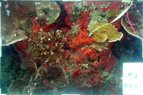
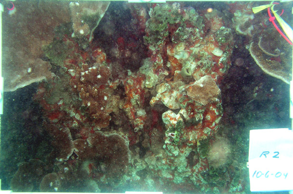
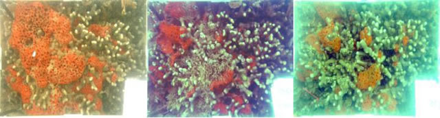
Mycale armata overgrowing the coral Montipora capitata on Coconut Island south reef.
| Objectives | Methods | Results | Conclusions and Future Work | Staff & Associates | Acknowledgements |
Mycale armata Thiele is an introduced sponge first described from specimens collected from the Molluca Sea, Indonesia that is considered a potential invasive threat to corals and reefs in Hawaiian waters, where it is common in harbors and embayments. It was first reported in Hawai‘i from Pearl Harbor in 1996, where it was especially prominent in the vicinity of the Hawaiian Electric thermal discharge in Pearl Harbor’s East Loch. It was one of the more frequently occurring introduced invertebrates on the 2003 HCRI rapid assessments of introduced species on coral reefs in the main Hawaiian islands, where it was reported at 5 of the 41 sites surveyed. Most of these locations were relatively close to harbors or in Kāne‘ohe Bay, where the sponge occurred at both of the two sites sampled. In a more extensive Kāne‘ohe Bay study conducted in 1999-2000, it occurred at 4 of the 24 sites sampled in the bay, and these were all in the south basin. The Guidebook of Introduced Species in Hawai‘i reports that the sponge appears to be overgrowing corals in Kāne‘ohe Bay, especially the finger coral Porites compressa Dana and rice coral Montipora capitata (Dana), the two dominant reef-forming coral species in Kāne‘ohe Bay.
Observations by Hawaii Institute of Marine Biology (HIMB) staff and students familiar with Kāne‘ohe Bay suggested that Mycale armata had been increasing in abundance in the bay in recent years. Therefore, a study funded by the Hawaii Coral Reef Initiative (HCRI) and conducted by Bishop Museum staff was implemented in 2004 to determine the distribution and degree of invasiveness of the sponge throughout Kāne‘ohe Bay.
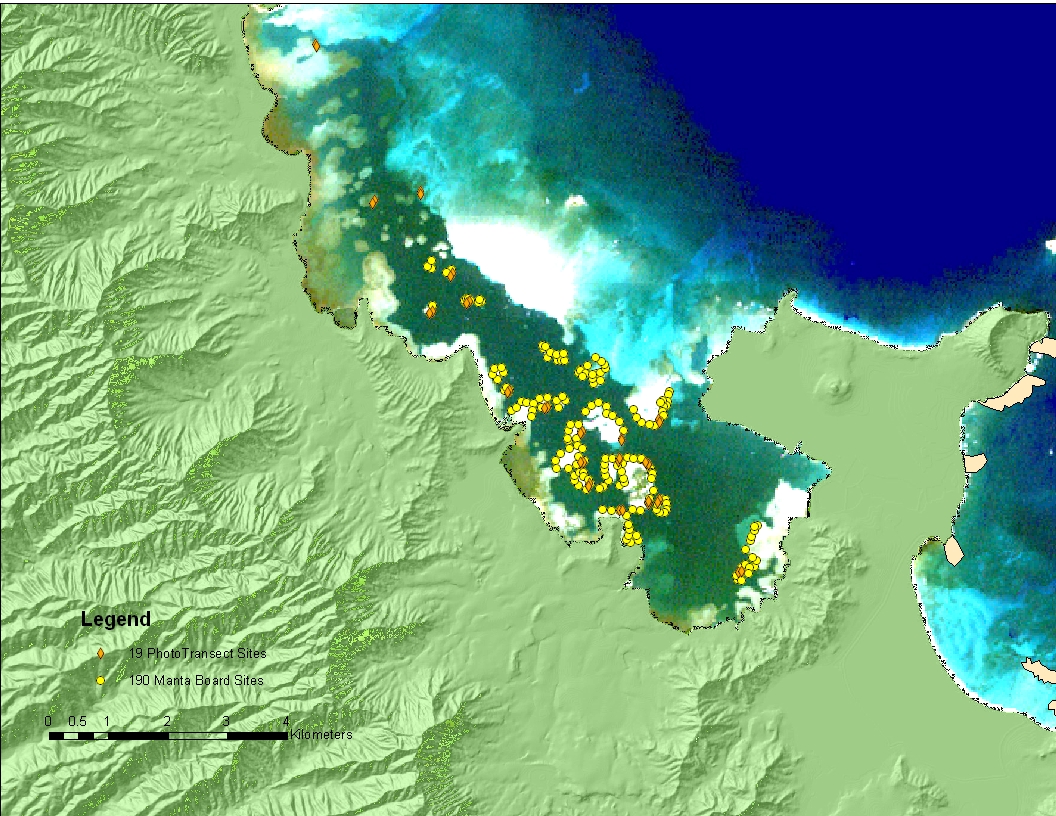
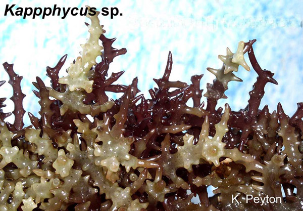
The Global Coral Reef Monitoring Network's (GCRMN) manta board procedure described in the Methods for Ecological Monitoring of Coral Reefs, in which a trained observer is towed for two minutes behind a small boat, was modified to a snorkeling observer swimming with the manta board along the reef edge. This modification was found to be more feasible in Kāne‘ohe Bay because of the difficulty in towing behind a boat under the prevailing wind conditions and the general murkiness of the water in the bay. The manta board swims were a satisfactory and time-efficient method for rapidly acquiring a substantial quantity of semi-quantitative distribution data for dominant benthic organisms. The observer estimated and recorded the coverage of Mycale armata, the two dominant corals Porites compressa and Montipora capitata, the introduced feather duster worm Sabellastarte spectabilis and the invasive algae Dictyosphaeria cavernosa, Gracilaria salicornia, and Kappaphycus sp. observed on reef crests and slopes during four minute snorkel swims along the edges of reefs in the south, mid and north sectors of Kāne‘ohe Bay. The relative abundance of each these species was estimated and recorded using the GCRMN scale ranging from 1 (1-10% cover) to 5 (75-100% cover). The location of the beginning and end of each swim was recorded using a Garmin 76 WAAF Global Positioning System (GPS) unit accurate to ± 8 m carried by the manta board observer in a waterproof bag . Using this technique 190 manta board transects were completed on 28 reefs by three observers in 13 days.
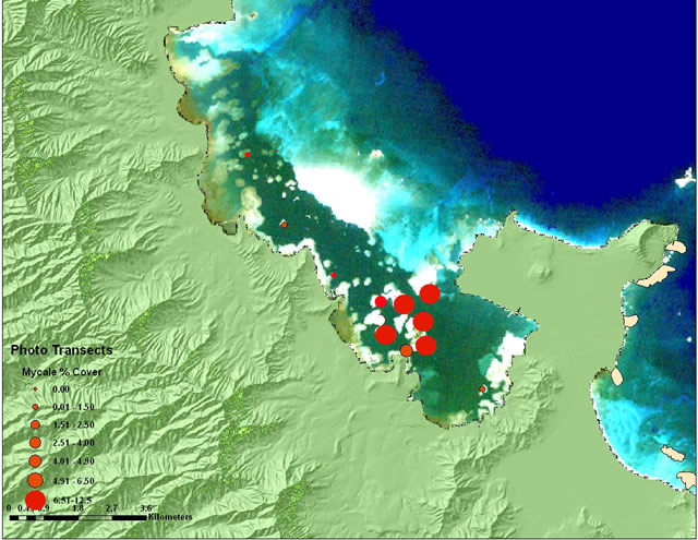
Data from the manta observations and the GPS locations were merged and entered into a Global Information System using ArcGIS and plotted on map layers which showed the distribution and relative abundance of Mycale armata in Kāne‘ohe Bay, along with relative abundance of other major plant and animal benthic components.
Having established the extent of the sponge in the bay using manta board swims, linear photo transects were used to establish the areal coverage of Mycale armata and other dominant benthic biota along transects at 19 sites on 18 reefs throughout Kāne‘ohe Bay. Digital photographs of bottom cover were taken along belt transects using an Olympus 5060 digital camera contained within an underwater housing and held on a fixed height camera stand, producing an image area of ca. 0.66 m2. Twenty-five photographs were taken on each of two transects per site for a total of 33 m2 reef surface measured per site. The start and end of each set of transects was recorded using GPS and mapped using ArcGIS.
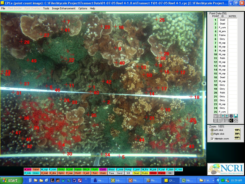
Images obtained were enhanced and cropped to a consistent size of 0.66 m2 and processed using the Coral Point Count with Excel extension (CPCE) program available from the National Coral Reef Initiative (NCRI). Each quadrat was assigned 50 random points and the composition under each point was recorded, for a total of 1250 points analyzed per transect or 2500 points per site. These data were used to determine the percent cover of Mycale armata, corals and other invertebrates, and substratum types within the photoquadrats, which were averaged at each site.
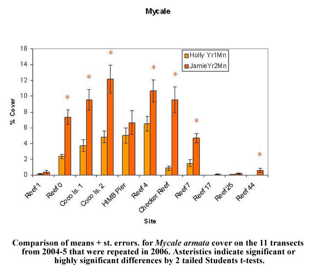
The linear photo transects method used in 2004-5 to quantitatively determine coverage of Mycale armata and other dominant benthic biota along transects at 19 sites on 18 reefs throughout Kāne‘ohe Bay was repeated in 2006 at eleven of the sites previously surveyed.
Twenty permanently marked photoquadrats were established on the reef slope along the southeast perimeter of Coconut Island to monitor sponge growth and competition with reef corals within the marked areas. The corners of each 0.165 m2 quadrat were marked with iron rebar or cable ties, enabling quarterly measurements of the same reef area for each quadrat throughout the year. No sponge was removed from 10 of the quadrats (Controls), while all the sponge that could be mechanically extracted from the remaining 10 quadrats (Removals) was removed. The amount of sponge removed averaged an equivalent of 1.85 kg dry wt per m2 for the ten quadrats. This was time-consuming and impacted corals within some of the quadrats, requiring an equivalent of 12.6-22.7 hr m-2 for removal from a single quadrat and removing an equivalent 0.18-1.72 kg m-2 of live coral skeleton as by-catch from six of the ten removal quadrats. Both sets of quadrats were photographed soon after sponge removal and quarterly thereafter using a digital camera on a stand with a fixed photographic area of ca. 0.165 m2.
After cropping to a consistent image area of 0.165 m2 the CPCe program was used to analyze the coverage of all components within the permanent photoquaduats for each quarter's determinations in a similar manner as was done for transect photoquadrats, except that 100 points evenly spaced in a grid were used for analysis of each quadrat. This stratified approach provided greater sensitivity and probability that the same specific areas on a quadrat were being sampled each quarter, resulting in more replicability for time-series analyses of changes within the permanent photo quadrats.
Two more control and removal quadrats were established in March 2007, and sponge was removed from the removal quadrats by a combination of first mechanical removal of the sponges surfaces, followed by injection of the sponge with compressed air from a scuba tank delivered through a 10 cm long bone necrosis needle inserted into the sponge tissue. Use of the needle enable delivery of the air down to the base of sponge growing on coral surfaces within the interstices of coral branches without disturbing the coral itself.
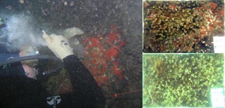
Four more removal quadrats were established on May 17, and these were injected with air without previous mechanical removal of the sponge surface, to determine whether air treatment alone was sufficient to effectively eliminate sponge from a reef surface.
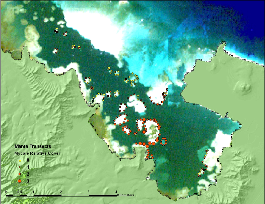
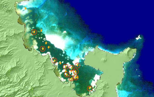
The manta board surveys indicated that Mycale armata has its greatest abundance in Kāne‘ohe Bay in the vicinity of Coconut Island and decreases substantially in all directions from that area. The greatest mean abundance determined by this method occurred along the reef adjacent to the HIMB Pier, closely followed by Coconut Island reef and nearby Reef 4. No Mycale was observed north of Kahalu‘u and very little along the northeast side of the main channel north of Coconut Island.
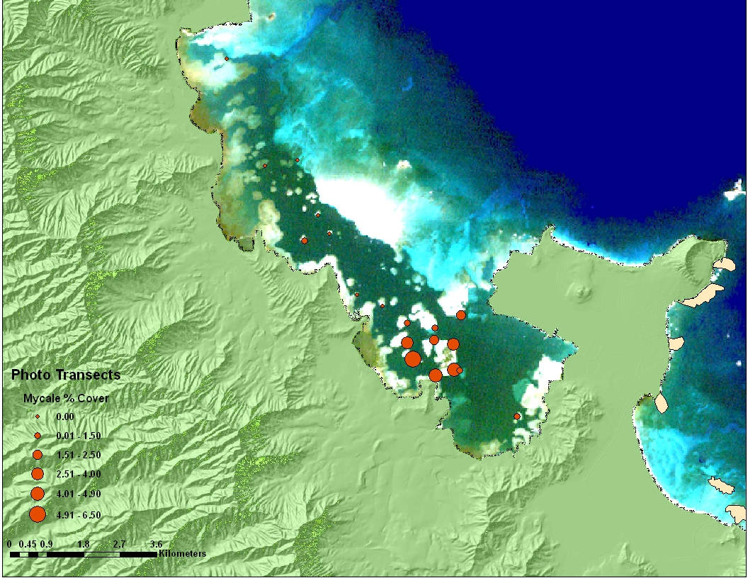
Quantitative measurement using photoquadrat transects on 19 selected reefs in 2004-2005 confirmed the pattern of Mycale armata distribution previously determined from manta board surveys. The highest value determined for any transect was 9.2% at Reef 4, with a mean of 6.5% for the two transects at that reef. Mean values for nearby Coconut Island and HIMB dock reefs ranged 4.5-5%, and cover decreased substantially with distance from this area to less that 1% at 1-3 km from Reef 4. Overall, Mycale coverage averaged only 1.7% on the 19 sites surveyed By comparison reef coral and macroalgae showed substantially higher coverages at all sites, ranging up to 30% for total macroalgae and 89% for total coral with respective means of 7.8% and 35.3%. Coral was the dominant live bottom cover at all sites except at four reefs in the central bay where macroalgae with a large component of introduced and invasive species made up the major portion of the benthic biota.
Comparison of the manta board relative abundance and phototransect survey percent cover results indicates a high correlation of between the two methods of estimating Mycale armata coverage. Both methods showed the highest abundance in the vicinity of Coconut Island with decreasing coverage with distance from this area.
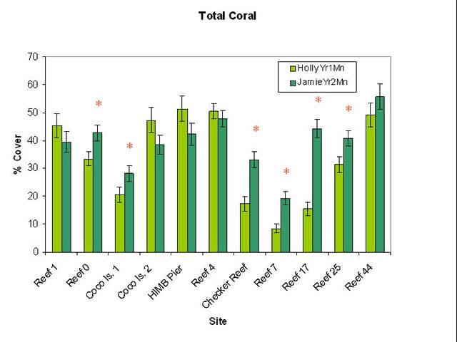
Results of resurveys of 11 of these reefs in 2006 from analysis of photo-transects by J. Marchetti showed increases in Mycale armata cover at all of the reefs, and eight of these increases were found to be significant or highly significant. The highest mean value determined for two transects at any reef was 12.2% at the Coconut Island 2 reef, more than 2.5 times its previous mean value and more than twice the maximum value that had been measured for any reef (i.e. 6.5% at Reef 4i) n 2004-2005. Overall, the results showed Mycale to have increased substantially at many sites, with the greatest increase on the south side of Checker Reef. At that site sponge coverage determined from May 2005 photo transects was <1% coverage and coverage determined from anlysis by J. Marchetti for September 2006 photo transects was 9.5% in September 2006.
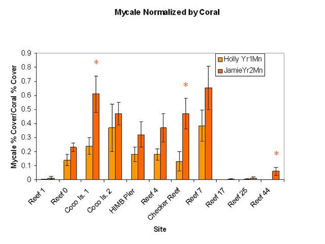
Results for changes in total coverage also showed increases at seven of the eleven sites, with these increases significant or highly significant at five of the sites (see figure above). Coral coverage is shown to have doubled at three of the sites (Checker Reef, Reefs 7 and 17), which suggests that the placement of transects in 2006 may not have exactly coincided with transect placement during the first year's measurements. This could be a source of error between the sampling periods. Although use of GPS coordinates and field notes assured that the transects were replicated within a few meters of their original location, slight differences in lateral placement or depth of a transect could result in major differences in results. This was tested by normalizing the Mycale coverage results by dividing Mycale values by total coral cover for each quadrat. Results for analysis of 2006 quadrats indicate that Mycale in terms of coral cover increased at all sites similar to the pattern found for Mycale alone and that these increases were significant at three of the sites: Coconut Island 2, Checker Reef and Reef 44, where no Mycale had been detected on transects in 2004 (see figure below). Therefore, both raw Mycale coverage and Mycale normalized by coral suggest that the sponge was increasing cover at many sites in the south bay from 2004-5 to 2006.
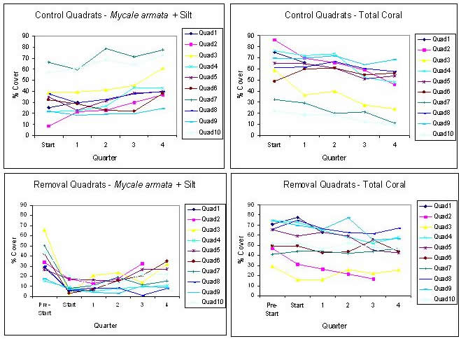
Nine of the 10 control and eight of the 10 removal permanent photoquadrats remained by the time of fourth quarter coverage measurements in November 2005 at the end of the first year of the study. Although there was some variability in changes between quarters for individual quadrats, the overall trend showed consistent increases in Mycale armata + silt for most control and removal quadrats and decreases in total coral compared to their initial values. (Silt coverage was lumped with Mycale coverage because large potions of the sponge were periodically covered with silt). All nine of the control quadrats remaining by the fourth quarter showed increases in Mycale coverage while eight of the nine showed decrease total coral cover. For the removal quadrats, sponge removal in October-November 2004 reduced Mycale cover on quadrats by as much ca. 65% of the total quadrat surface area. All quadrats showed regrowth by the fourth quarter, with two quadrats having recovered to virtually their pre-removal values. In most cases removal of sponge from the quadrats was followed by some degree of continuous decline in coral cover, with six of the eight quadrats remaining by the fourth quarter showing reduced coral cover compared to pre-removal levels.
Six control and seven removal quadrats were still present at the end of the study in November 2006. Thee first-year trends of increasing Mycale cover and decreasing coral determined continued, but at a more moderate rate, during 2006. The significant increases of 13% (p<0.001, paired t-test) in average Mycale+silt coverage and 16% decrease in average coral for the control quadrats during the first year decreased to a non-significant average increase in average sponge cover of 1.7% and a decrease in coral of 3.7% during the second year on control quadrats. On the seven removal quadrats remaining by the end of the study sponge cover increased an average of 6% of qudrat area and coral cover decreased by only 1.4% of quadrat area from the previous year's end values.
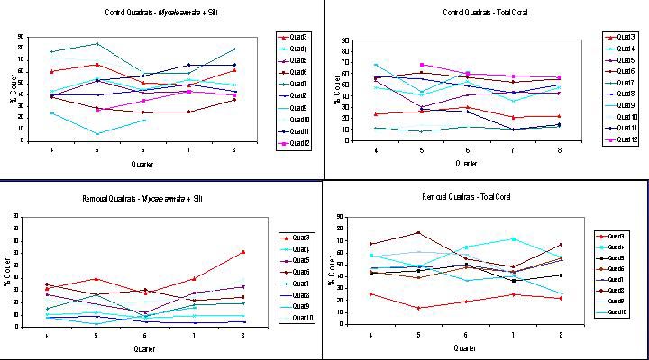
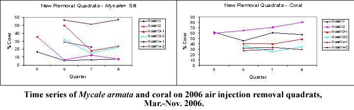
The new removal quadrats that were established in March 2006 and had air injection treatment after preliminary mechanical removal of sponge surfaces remained through the end of the study. Sponge removal by this method required an equivalent of an average hr m-2, substantially less than the nearly 22 hr m-2 average for the mechanical removal method previously used in 2004. Four more removal quadrats were added on May 17 2006 for which air injection alone was used to remove sponge. Little change was noted on these quadrats when they were next seen on July 10, and the air injection was repeated. This second treatment substantially reduced sponge on all four quadrats by August 4 and three of these four remained to the end of the study in November. Sponge removal by this method of air injection without prior mechanical surface removal of sponge averaged an equivalent of ca.1.4 hr m-2.
Similar reductions in sponge cover were achieved from both methods, resulting in decreases of 48% (below initial values in the first quarter following treatment, and 42% for the five quadrats remaining at the end of the study. Both methods also produced less coral damage than mechanical removal alone. Coral cover was reduced only 6.9% below initial values in the first quarter following air injection and by 8.1 % by the end of the study.
Baseline measurements of the extent of occurrence and bottom coverage of Mycale armata in Kāne‘ohe Bay indicate that at present the sponge is confined to the south and central bay, with its highest coverage on reefs in the vicinity of Coconut Island. Although it is a visually compelling component of the benthos and does overgrow reef corals, it was patchily distributed and showed a maximum coverage of less than 10% on any reef measured in 2004-2005. Coverage decreased dramatically in all directions to less than 1% of the bottom at 1-3 km from the sponge's epicenter.
However, both the highly precise photo quadrat measurements and the less precise but more extensive photo transects suggest that Mycale armata is increasing its coverage on reefs in south and central Kāne‘ohe Bay, and that corals on these reefs may be in process of being gradually overgrown by the sponge. The mean Mycale coverage on the 11 photo transects resurveyed in 2006 more than doubled from the first to the second years measurements from 2.3% to 5.6%, with significant increases at eight of the eleven transect sites. More importantly, the ratio of sponge to coral approximately doubled. This analysis is the most definitive evidence of increase for the transect data, since it at least partially corrects for the error inherent in not precisely replicating the location of the transect line for the second years measurements.
Quarterly measurement of changes in sponge coverage on permanently marked quadrats along Coconut Island's southeast reef suggest that Mycale armata is gradually increasing in abundance at a quite steady rate during the first year, although changes were inconsistent on some quadrats during some quarters. Overall, both undisturbed control quadrats and quadrats where all sponge feasible had been removed showed consistent trends of increased sponge coverage after one year. All nine of the remaining control quadrats showed sponge area increases, and seven of these had decreased areas of coral cover, suggesting that Mycale armata is gradually outcompeting and overcoming reef corals in this area of maximal sponge abundance. A similar trend occurred for removal quadrats, where eight of the nine remaining quadrats had substantial regrowth of sponge above post-removal values by the third or fourth quarter, and sponge on two quadrats had recovered to pre-removal coverages. These sponge increase rates decreased during the second year, although small increases still occurred on most remaining control and removal quadrats.
Air injection of the sponge substantially reduced the time required for treatment and was less damaging to corals. Air injection may provide a potential means of controlling Mycale growth and spread of in Kāne‘ohe Bay. Further testing of this method is needed to determine its long-term effectiveness and resource requirements, since sponge re-growth after air injection treatments occurred at comparable rates as followed mechanical removal. On a small scale, additional removal quadrats could be deployed and the frequency of air injection needed to permanently reduce sponge cover determined. An additional pilot study investigating the effectiveness of the method a the scale of a small reef invaded by Mycale might also assist in refining this technique for its development as a new control tool for marine sponges, including as a rapid response tool to a new introduction.
Dr. Steve Coles, Bishop Museum, Project Manager
Mr. Tony Montgomery, Hawaii State Department of Natural Resources/Division of Aquatic Resources (DLNR/DAR), co-investigator
Mr Jamie Marchetti, DLNR/DAR Invasive Aquatic Species Response Team, Research Assistant
Ms. Holly Bolick, Bishop Museum, Research Assistant
Ms. Adrienne Romanski, Columbia University, Project Intern
Hawaii Coral Reef Initiative (HCRI)
National Oceanic and Atmsopheric Administration (NOAA)
Hawaii Institute of Marine Biology
DLNR/DAR Invasive Aquatic Species Response Team
Steve Carroll, Southern California Aquarium Society, for initial idea of using air exposure as a sponge control